Tuesday, February 15, 2022

Trying to enjoy the snow and ice while it is here...


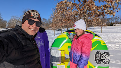
Summer and I enjoyed some time sledding on our recent snow. I even blew up the innertube, but that typically happens for the last big snow of the season. So we will see. I hope we have one more big snow to enjoy some time sledding, but time will tell. Anyway Summer and I had a blast on the hills. Evan is not a big fan yet of sledding, so he was taking a nap.
Here is an updated to 
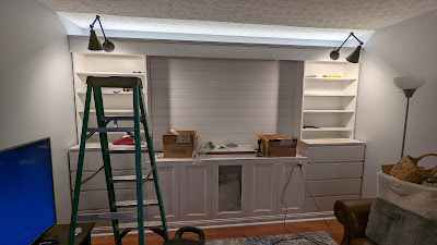
my last blog about building a built-in entertainment center. Things have been coming along, but I did not get it done before our ice/snow storm. I ended up having to park outside while the garage was the "work area"
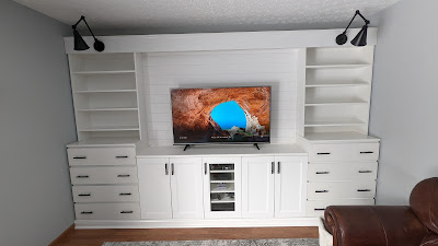
All-in-all it was a pretty reasonable price to build a lot of this using pieces from Ikea. I did build a platform to raise it all up off the ground a little bit. The TV looks pretty small in the middle there now. I am going to let it stay there for a few weeks to settle before trimming out the edges. Everything is locked into the wall tight, but just in case there is any settling. 
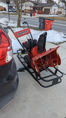
On to my next project... A good friend saw a free snow blower on the curb, while they were walking. They took it home and called me up. I am going to do my best to get it running again. Been a while since I worked on small motors, but I love a good challenge. Time to bust out all my moped tools for some fun!
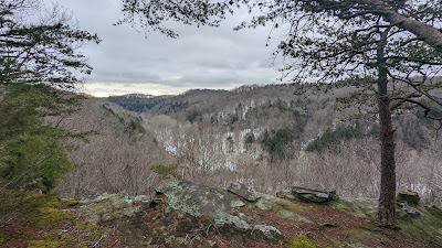
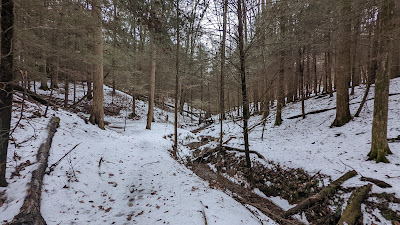
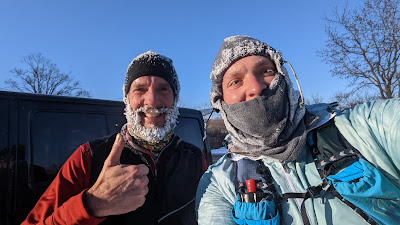
I did go running at Clear Creek Metro Park over the weekend. Some trails were normal with just dirt, leaves, and sticks. 
Other trails were extremely dangerous. The north slopes were still ice chutes. They had a lot of sleet and ice a week before and we did have one day of melting and light rain to solidify the ice. It was a slow 4 hours on the trails, but it was good practice on what to do if put in a race situation similar to this. I did buy some crampons to strap on to my shoes with metal spikes to dig into the ice. Wish I had them on Saturday. 

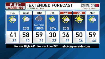
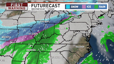
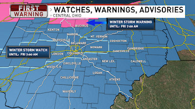
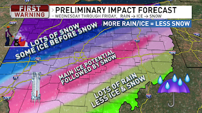
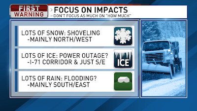
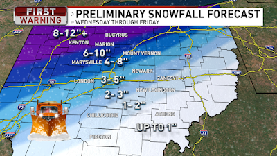
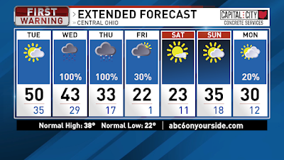
Cold morning with calm winds. Temps are starting off in the lower teens and we will warm to the low 40s this afternoon with partly cloudy skies. Tonight temps stay in the mid 30s for more slowly melting. Winds pick up out of the south on Wednesday and that will help push our temps into the upper 50s. We will start the day partly cloudy and become mostly cloudy. A few rain showers possible, to the northwest, late Wednesday, but most of the area will remain dry. More rain Thursday. Rain will be persistent a lot of the day and rainfall likely around 1”, which could lead to some flooding issues because the ground is still frozen with lots of ice. Cold air races in fast Thursday evening and we may change over to a wintry mix and light snow on the tail end of the system. The majority of the event will be rain and the ice and snow will not last nearly as long as the event two weeks ago. We will keep an eye on timing of the change-over, but right now any ice and snow accumulations look to be light compared to the rain. A few snow showers early Friday morning then become partly cloudy with highs around 30. A weak clipper will swing through the Great Lakes on Saturday and there is a slight chance for a few snow showers or flurries Saturday, mainly north. Highs in the mid 30s on Saturday. Sunday will be mostly sunny and we warm to around 50 by the afternoon. Monday we warm into the upper 50s with partly cloudy skies. Have a good one!

Best,
Andrew Buck Michael

Wednesday, February 2, 2022

Update on our winter storm

I was busy yesterday starting to build our new entertainment center built-in. But I built the platforms to raise it up a little and attached it all together. Today I am going to try to finish the bookshelves and the mantle going across the whole top.  The goal is to get all the garage cleaned up so I can park back in the garage before the snow and ice.
Looks like a rainy day to try to wrap it up. Temps will be in the low-mid 40s all day today with rain arriving by midday. Temps fall fast tonight and the rain will change to freezing rain and snow through the night and day tomorrow. 

The temps are looking a little colder tomorrow and that has shifted the snow totals and ice totals a little farther south.
Here is a look at the ice totals for Thursday.
This is also a look at the snowfall totals by midday Friday. 
Here is a more detailed write-up for what is on the way... We are cloudy with temps in the lower 40s and our temps will only warm into the mid 40s today with a cold front moving through this afternoon. The cold front will bring rain showers by midday and we will see rain through the afternoon and evening. Colder air starts moving in from the northwest this evening and the rain briefly will change to ice then snow. Overnight that ice line will make its way to the I-71 corridor from Cincinnati to Columbus to Cleveland. The ice will continue to expand towards Southeast Ohio by daybreak with ice from I-71 corridor down towards Southeast Ohio. North & west of the I-71 corridor we will have snow through the day tomorrow and that snow will slowly work its way to the southeast as well. So we will all likely see some ice as we go from rain to snow, but the heaviest ice potential has shifted a little farther south, into Southern Ohio. With the southern shift in the heaviest ice that also means that our snowfall totals have shifted south a little more. The snow continues Thursday night and wraps up Friday morning. NW Ohio will see 7-12” of snow by midday Friday. From Cincinnati to Columbus to Youngstown, the swath will see 3-8” by midday Friday, then lower totals for Southern/Eastern Ohio due to a longer duration in the ice. Keep in mind that a 1° or 2° shift will adjust the snowfall totals.

Once the snow ends on Friday the focus will be digging out and also staying warm. Thursday the temps will fall slowly through the lower 30s into the 20s, but by Friday we will have high temps in the lower 20s. Friday night we anticipate temps below zero with clearing skies. Saturday will be mostly sunny with highs in the lower 20s again. More sun on Sunday and warming to the lower 30s. Clouds return on Monday with a slight chance for flurries or light snow with highs around 30. Have a good one!

Best,
Andrew Buck Michael

Tuesday, February 1, 2022

Winter Storm arriving soon!

Had a great long run with my buddy Mike on Saturday. It was 4 degrees when we started with a light breeze. He had a beard that was covered in ice to keep his face warm. I had to resort to covering my face. Clear and cold morning... but that is NOT what is on the way for us later this week.

A developing winter storm will move in for the second half of the week.
Winter Storm Watch for all of Ohio thru Friday morning. Some counties have started upgrading to the Winter Storm Warning. Rain Wednesday changing to ice and snow for Thursday into Friday.
Rain moves in Wednesday and starts transitioning over to snow in NW Ohio by Wednesday night. Then that transition area widens for icing near the I-71 corridor on Thursday with snow NW and rain SE. The transition area of ice moves SE Thursday evening and we all transition over to snow Thursday night and early Friday. The whole system gone by midday Friday then turning much colder.
Thursday is the tricky situation. Cold air will funnel in near the ground while it will be warmer above us.
So the transition line will become wider for freezing rain and sleet (ice pellets) This icing area will generally go from Cincinnati to Columbus to Youngstown and some of the heaviest ice looks to be just a little south/east of that line. So during the day Thursday we will have ice along this line with rain in S/E Ohio and snow still falling in N/W Ohio. Accumulations of ice could be upwards of half an inch, which would coat powerlines and trees. Add in some breezy winds on Friday and there is potential for power outages by Friday. The icing line continues to drift very slowly towards S/E Ohio Thursday evening while Central Ohio goes from ice over to snow. By Friday morning the snow is wrapping up and moving off to the east. 
Northwest Ohio will see the heaviest snow with 8-12”+ likely. But areas that see prolonged icing will see significantly less snow. There will be pockets of warmer or cooler air, so take the forecast with a grain of salt because 1 extra hour of sleet will result in 1” less snow. Following the ice along the Cincinnati to Columbus to Youngstown there could be an additional 3-5” snow and S/E Ohio seeing even less snow because of the prolonged rain then ice and by the time the cold air arrives for snow then most of the system is moving off to the east and out of here, by midday Friday.
Friday and Saturday will be very cold with highs in the lower 20s and morning low temps around 0. Skies will become partly cloudy later Friday into Saturday. We will also have a brisk breeze out of the north to drive wind chills even colder plus give us the potential for power outages with the icing. Sunday we start warming back into the mid 30s and a slight chance for a few flurries Sunday night into Monday.

Stay tuned to the forecast adjustments because if the colder air arrives faster or slower then it will adjust where the heaviest icing will occur and impact the snowfall totals greatly. Have a good one!

Best,
Andrew Buck Michael

Back to the main page