Monday, January 24, 2022

Saying goodbye to GG. More snow on the way for us...

It was a sad week last week, saying goodbye to Dawn's grandma. We called her GG for Great Grandma. This photo is from last year at a wedding. She was a ray of life and her two pillars in life were her faith and her family. 
 
I signed up for the Rocks and Roots 50k race last weekend. I found out during loop 3 of 5 about GG's passing and called to talk to my wife and could tell she was very upset. She insisted that I finish, but family always comes first, so I went home to be with her and family. I will be back in February to run the second Rocks and Roots race, for their winter trail series. No snow on the the ground last weekend...

Quite different this weekend. I ran around Quarry Trails with a friend yesterday. It was fun running in the light snow. 
The kids and I did go sledding last week. They were quarantined due to COVID, so no kids on the sledding hill, while school was in session!
We spent a lot of time in the snow last week, actually. Not for too long, but I am glad they are willing to go outside and enjoy winter.
We have also spent a lot of time inside as well. I am teaching Summer to play chess with No Stress Chess. We get pretty competitive and we are splitting the wins now. 
Hopefully we can get more snow to make the sledding conditions great!
You may remember a blog entry I wrote a few weeks ago. I looked back at the abnormally very warm December and the top 4 other warmest Decembers were all followed by less snow than normal. This month looks to be much of the same. We have only picked up 2.9" of snow so far and we normally average 9.5" of snow in January, in Columbus, Ohio. 
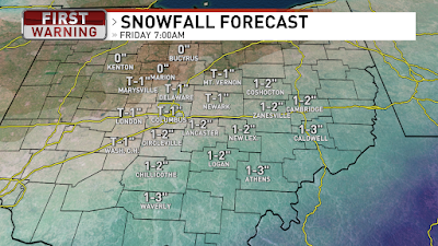
Another clipper system will bring another round of light snow today. The early morning commute will be dry, but be mindful of slick spots from Sunday’s snow. Today we will see another round of light snow showers for the late morning through the middle of the afternoon. 

Generally 1”-2” of snow today and less to the south because it will be warmer for the chance of some wintry mix and even some rain possible. 
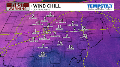
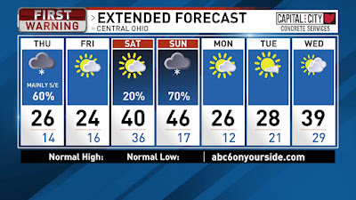
Temps are in the teens now and will warm slowly through the day and we will get our high temperature in the evening, around 34, then temps fall fast overnight once a cold front swings through. Winds will be out of the south today, helping to warm us up, then change to the northwest overnight once the cold front swings through. A few flurries possible Tuesday, but generally dry, with morning temps in the teens and warming into the mid 20s. We will have a mix of sun & clouds Tuesday. Colder Wednesday with partly cloudy skies. Morning temps in the single digits on Wednesday and a high of 19. Similar on Thursday morning, but we do warm up more to around 30 for the high. By Friday we will have another clipper with some light snow showers. The Friday snow does look to arrive in the morning/midday, so earlier than today’s snow. Highs in the upper 20s on Friday then dry Saturday with mid 20s for highs. By Sunday we warm to the mid 30s with mostly cloudy skies and a slight chance for light snow late. Long-term outlooks are indicating highs above freezing next week for some slow melting as we head into the start of February. Have a good one!

Best,
Andrew Buck Michael

Thursday, January 6, 2022

From sun... bitter cold... to snow... Welcome to winter, Ohio!

Tuesday was about as beautiful as you can get in Central Ohio in January. Temps were in the lower 40s with just a light breeze. Sunshine and blue skies! WOW! I went for a run around the neighborhood and could have kept going on forever. Well... maybe not for...ever...
It would be a VERY cold morning for a run today. These are the wind chills at 5AM. Coldest temps of the season, so grab the coat, hat, gloves, and scarf today.

There is an area of low pressure in Kansas moving into Missouri and that will swing through Kentucky today and into West Virginia tonight. Ohio will be on the northern edge of the storm with snow from midday to midnight. Snowfall totals, by Friday morning, for Southern/Southeastern Ohio will be around a couple inches and even more snow near the Ohio River. Central Ohio will see around half an inch, with less to the northwest and more to the southeast. High of 26 today then tonight we will drop into the mid teens with wind chills in the single digits again. Friday we will have a high of 24 with clouds in the morning and then some sun by the afternoon. A few flurries also possible early Friday.

Partly cloudy on Saturday with temps in the teens for the morning then warming up to around 40 for the high. Rain moves in Saturday night and rainy for Sunday morning with a chance of a wintry mix midday/afternoon on the tail end of the rain. So wet & cloudy with highs in the mid 40s on Sunday. Next week will start the week very cold Monday and Tuesday, with highs in the 20s. Partly cloudy as well for Monday and Tuesday. More clouds Wednesday with highs in the upper 30s. Have a good one!

Best,
Andrew Buck Michael

Tuesday, January 4, 2022

Let's kick off 2022 with some snow!

Good morning! Spent the weekend in the Cleveland area to celebrate Christmas with my wife's family.  The city center in Strongsville is a tradition to see all of their light displays.  Their wrapped trees had to require hours of work and so much patience. Mad respect! We all were in bed before the ball dropped Friday night. HAHA!
I ran out of my hair balm right on the near year so I can do an experiment on how long it will last me. My guess is at least 3 months. 
We will see a few passing clouds today, but still lots of sun. We are starting off with temps in the lower 20s with frost, but the sun and a light breeze out of the south will help warm us into the lower 40s. More clouds tonight and overnight lows in the mid 30s with winds picking up, out of the south. 
A cold front will swing through Wednesday and it will cause our winds to be brisk out of the southwest 15-25 mph with gusts 30+. A stray light shower possible Wednesday and temps will be right near the rain/snow threshold.
Thursday will be cold & mostly cloudy and then snow showers possible during the afternoon, evening, and overnight. The system is still more than a thousand miles away. The track can slightly adjust coming over the Rockies and that will not occur until midday Wednesday. The track of the system looks to bring more snow for Southern/Southeastern Ohio. 
Right now it looks like areas in Southern Ohio could see a couple inches of snow, or more. We will dive more into the projected snowfall totals as the storm gets closer. Snow kicks out by daybreak on Friday. It will be cold for the end of the week with highs in the mid 20s on Thursday and lower 20s on Friday. Partly cloudy on Friday. Temps warm up into the mid 30s on Saturday with partly cloudy skies. More clouds on Sunday with highs in the mid 40s. We will see rain showers on Sunday. Colder air rolls back in on Monday.
So far, Columbus has picked up 1.1" of snow since Summer. That is about 6" behind normal, but there is plenty of winter left. This graphic shows the snowfall totals over the last 12 years. As mentioned... plenty of winter left to go! Have a good one!

Best,
Andrew Buck Michael

Back to the main page