Wednesday, July 9, 2025

Hilltop USA 5k & stuck in an unstable weather pattern

We did it!  Summer shaved off about 90 seconds from her best 5k time! I love this photo that a good friend Heidi took while Summer and I were running the race. 

I helped emcee the race again and it is always so great to meet and see so many people out at the race. Plus it is an affordable race with any extra proceeds going to help the veterans of the Hilltop. 
Last week my sister called and asked if I wanted to meet them at Young's Jersey Dairy in Yellow Springs. I had planned on taking the kids to the pool, but a day of fun sounded like a great option too. My parents also came and we had a great time playing a couple rounds of putt putt, driving range, batting cage, and other attractions. We had lunch at first, but decided to work up an appetite for ice cream and we timed it out when some rain came through. We had a quick downpour then went back out for more fun. 
My dad loves to play putt putt, so he had a lot of fun. It is always great to spend time with family, especially on days that you weren't planning on it. Gotta cherish those days!

Summer was in the Hilliard 4th of July parade with her Girl Scout troop. They did a great job with their float and were recognized for it. 
We didn't buy and fireworks, but maybe we change that next year because the kids got such a kick out of the handful of fireworks that my neighbor set off in their driveway. Gotta love the nation's birthday!
Our weather pattern for Central Ohio will remain the same for the rest of the week, weekend, and early next week. Staying hot & humid the rest of the week and weekend. Isolated showers and storms will be possible time to time. We will remain very warm to hot, 86 to 90 for high temps and morning lows around 70. The hottest days appear to be later this week and start of the weekend as we push closer to that 90-degree range. We will also remain muggy with dew points in the upper 60s and lower 70s to make it feel sticky and not very refreshing. The heat and humidity will help to fuel occasional rain in pockets across the area. The chance of rain for the next 7 days fluctuates between 30% and 40% each day. The best chance of rain will be in the afternoon when it is the hottest, but overnight and morning rain is also possible. The good news is that severe weather is not likely for most of the rain. A few storms may become severe with gusty winds or hail, but most of the rain will be run-of-the-mill garden variety showers and storms. Since the rain will be isolated, and not widespread, rainfall totals will vary greatly within a short distance. Generally, we expect an inch or less of rain, on average, over the next 7 days, but a few pockets that happen to experience a few downpours may exceed that. We get Florida weather without the beach… or alligators. Have a good one!

Best,
Andrew Buck Michael

Wednesday, June 25, 2025

Beating the heat. My favorite type of weather is here!

The hottest temps of the year are here! Over the weekend I went on a run with Summer (Evan rode his bike) along the Camp Chase Trail in west Columbus. I am emceeing the HilltopUSA5k again this year and Summer is running the race with me again. So we went out to do a practice run on the course. We got out as early as possible, but it was still very warm and humid. 
We went up to Indian Lake after that and it was a beautiful day and sunset on the lake.
Sunday was a pretty chill day hanging out at the lake and trying to stay inside as much as possible because the heat index was over 100.
Monday we went to the library to get some books and yesterday was a pool day. By the late afternoon the water was already starting to feel warm, but at least it was still refreshing. We finally started having some clouds bubbling up to occasionally shade us.
This is my favorite weather of the year. Not the heat, but the type of weather that is causes: convective storms. The hot surface causes rising parcels of air and if it can break through a weak cap in the atmosphere then it keeps lifting and eventually can cause spotty showers and storms to develop. That cool wet air then falls to the surface with rain and downdrafts. That air then hits the surface and fans out, called an outflow and creates a barrier of wind pushing away from the storm. When the air fans out then it has to go somewhere and an easy place to go is back up with rising air parcels nearby. That nearby rising air then pops up new isolated showers and storms to develop and the process keeps repeating itself as long as there is enough heat & humidity, along with a weak cap. This type of weather is fun to watch because you can monitor the visible satellite midday to see where the clouds start bubbling up. The visible satellite will look like popcorn popping up midday. When I was an intern at WHIO, the meteorologist would say "The seed has been planted" when the first storms would pop up. Most of the pop-up rain occurs during the hot afternoon, but if outflow boundaries from two different storms collide overnight then occasionally you can get a nocturnal storm to pop up. I love it because it is somewhat sporadic, but sometimes there are things that trigger certain areas to pop before other locations. I posted a futurecast of how today is expected to pan out.  For today we have a very light breeze out of the west at 5 mph. Notice a lone thunderstorm pops up east of Columbus midday. The city is typically hotter and that warmer air lifts as it is blown east. So the best chance of rain to start firing up today will be on the east side of Columbus. I always love to see if that urban heat island lift pans out, or if another pocket in the area lifts earlier/faster. 


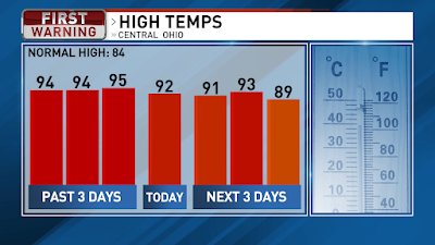
We hit 95 for the high yesterday, for the new hottest day of the year. Going forward the high temperatures will be slightly cooler, lower 90s, for the rest of the week and weekend. 80s return next week. We still have a Heat Advisory today because it will feel as hot as 100 or a little hotter this afternoon due to the high humidity. 
Today we have a 60% chance of rain with scattered showers and storms popping up starting midday through the early evening. The heat of the day will be the main trigger for the storms to start firing up. We are starting off with temps in the mid-upper 70s and we will warm to a high around 92 today. Areas that dodge the rain may get a little hotter. A few stray showers or storms possible this evening then most of the rain will take a break. We will repeat the process through the rest of the week and weekend. There is a slim chance for the storms to become severe with strong winds. Lots of lightning will be likely along with downpours. 
For tomorrow, Central Ohio will have a 60% chance of rain with the scattered storms and a high around 91. Friday there is a little less instability, and it looks like a 40% chance of rain with a high around 93. Back to a 60% chance of rain on Saturday with a high around 89.  Sunday will be a 40% chance of rain as we get a little ridge of higher pressure that may keep some rain from bubbling up. Sunday’s high will be around 91. 
Pressure drops as we head into Monday and Tuesday, thanks to an approaching cold front, for a 70% chance and 60% chance of rain as high temps drop back into the mid-80s heading into the middle of the week. Have a good one!

Best,
Andrew Buck Michael

Tuesday, June 17, 2025

Laurel Highlands Ultra volunteering & Father's Day weekend

I took a couple days off last week to rest up for the Laurel Highlands 70 miler, but I was not running, so I figured a sleepless night in the tent with the kids would be fun. They slept well on some cots from our neighbors, but I slept on the ground and I am really feeling my age. 
I smoked some ribs since they were on sale. They turned out delicious, but I had to delay eating them and they were a little drier than I would have liked. Everyone else thought they were fantastic. 
Then I was off for Pennsylvania. The laurels were blooming along the Laurel Highlands hiking trail. This race was supposed to be my Western States qualifying race, but because of my injury I had to back out of the race because I would not have made the 70 miles.
I did get out for a short run, before the race, along the trail with a couple of friends that were there.
Instead I volunteered a little Friday night then all day on Saturday. I had to be up at 3AM to get to the start of the race to set up the starting line and start checking in the runners.  I worked at Aid Station 2 and handled all the hydration needs of the runners. Mixing up electrolyte drink and keeping the drinks nice and cold for the runners. Met some awesome people at the race and can't wait to get back out on the trails more, now that I am recovering. 
Father's Day was a hot and humid day, as usual. I went on a run with Summer while Evan rode his bike. We set up a kiddie pool in the backyard and just relaxed. My brother Marcus was in town so he stopped by.
Marcus came back over on Monday and we played games and then went fishing. I accidently caught a turtle, but we safely got the turtle back in the water. Evan loves turtles, so he wanted to touch the turtle. Great few days. Good for the soul. Hoping to catch up on sleep soon. 

On and off rain & storms today, so grab the rain gear. We have scattered showers and storms early this morning and a few more rounds of this rain on and off today. Rainfall totals will be around half an inch today, but higher rainfall totals for areas that get a couple rounds of downpours. There is a flood watch for Southern and Eastern Ohio. We are starting off with temps around 70 and warming to a high around 82, if we get a long enough break in the rain. Severe thunderstorms, with damaging winds or large hail, are not likely today. The rain takes a break this evening and tonight with just a stray shower or two possible. We will remain humid tonight with patchy fog forming and dropping to a low around 70.

Wednesday will bring a chance for stronger storms. The chance of rain will be low in the morning then increase chances of rain as we go through the afternoon and evening. An approaching cold front will likely trigger storms later in the day tomorrow. Stay weather aware for late Wednesday for the potential of severe storms with damaging winds, large hail, or even an isolated tornado. We will warm up to a high around 88 for Wednesday with high humidity to make it feel like the lower 90s. Today’s winds will be light out of the southwest, but they pick up 10-15 mph for Wednesday. Scattered storms for Wednesday night and a few lingering showers or storms possible for the first part of Thursday. Lower chance of rain for the second half of Thursday, after the cold front has passed through. High temps around 82 on Thursday with humidity slowly dropping.

Hot to end the workweek then very hot heading into next week. Friday we will be partly cloudy with a high around 86 with moderate humidity. We will get very humid on Saturday with a high around 89 and partly cloudy skies. Mostly sunny Sunday and Monday with high temps around 93 and 94 with muggy humidity. Heat indices will be in the upper 90s. Have a good one!

Best,
Andrew Buck Michael

Tuesday, June 10, 2025

Lilies blooming, Summer's 10th birthday, sunshine returns!

I love this time of the year when the lilies start to bloom. This was from Friday, when they were just starting to pop some color. 
They are in full bloom now!
Like my new ride?  Just kidding. My father-in-law just retired and this is his retirement gift to himself. He let me take it out for a quick drive around the block. Super fun and smooth ride. 

In a side note, it is crazy to think I have a 10 year old today. Summer turns 10 today!?!?! I went back and re-read my blog entry from when she was born and it hit the heartstrings. 

We have a few pockets of fog this morning, but that will mix out quickly and we will have a mix of sun & clouds today. Morning temps are dipping into the 50s and we will warm to a high around 76 this afternoon. Clear skies tonight for a great viewing of the full moon. We will have some smoke in the upper levels of the atmosphere to potentially make the moon look a little larger and slightly alter its color, especially during moonrise and moonset. Temps dip back into the 50s overnight.

Sunny skies for Wednesday and Thursday. We will warm to a high around 83 on Wednesday then 86 on Thursday. Humidity will slowly go up each day as well. More clouds by Friday with a high around 84 along with higher humidity. There is a slight chance for some rain sneaking in later Friday. Rain is likely for the weekend and early next week. A stationary front will park over the region and that will bring bouts of rain from time to time for Saturday, Sunday, and Monday. Humidity will be very high, and it will be a swampy airmass between the rain. High temps in the low-mid 80s, after morning lows in the mid-upper 60s. Friday will bring a 30% chance of rain then a 60% chance Saturday and Sunday. Monday drops to a 40% chance of rain. Have a good one!

Best,
Andrew Buck Michael

Wednesday, June 4, 2025

Finally heating up. Bikes, fishing, smoke, & rain returning.

I spent the weekend hanging out with the kids. Evan graduated from Kindergarten on Friday and we had a fun get-together to celebrate him. Saturday we went to watch a neighbor play baseball then I went for a bike ride with the kids for a few miles. Sunday we had breakfast then I took the kids fishing for a few hours. We ended up catching about 25 fish. Almost all of them were smaller bluegill that we released, but we did catch a few small bass that we also released. It was a very slow start, but the kids were patient and it eventually paid off. 
It is crazy how much smoke we have from the Canadian wildfires. This photo was taken by my wife Saturday evening when I was driving west on 670 near downtown Columbus, Ohio.

Our air quality is worse this morning as some of the smoke in the upper atmosphere has descended closer to the surface. 
As of 3AM, most of the state is in the “moderate” or “unhealthy for some”, which would be a level 2 and 3 on a scale of 5, for poor air quality. Poor air quality is expected today, but improve tomorrow once the rain returns. 


It is a warm morning with temps in the 60s for most of Central Ohio and a few locations dipping into the 50s. You may also notice the humidity is a little higher this morning and it will continue to get more humid today and for the next few days. We will be mostly sunny today and heating up to a high around 87. More clouds will move in as we go through the afternoon and evening with rain staying to our west and northwest later today. Central Ohio will likely remain dry today with a high around 87. Increasing clouds overnight with temps falling to around 70. So a hot day today and a very warm night.

The scattered showers and storms will be popping up from time-to-time Thursday and Friday. We will heat up to a high around 82 on Thursday with a 70% chance of rain then a high of 80 on Friday with an 80% chance of rain. It will not be a washout, but we will have pockets of rain possible anytime each day.
There is a very slight chance for a few of the storms to become severe with gusty winds. 
Drying out for the weekend. Scattered showers early Saturday will be moving out then decreasing clouds. We will be a little cooler on Saturday, with a high around 77. Sunday will be partly cloudy and warmer, with a high around 80. Another round of rain returning on Monday with a brief cold front. Scattered showers and storms on Monday with a high around 81. Right now we are going with a 40% chance of rain, but that will likely need to go up as we get closer and confidence grows. Partly cloudy on Tuesday with a high around 76. Have a good one!

Best,
Andrew Buck Michael

Friday, May 30, 2025

Sourdough focaccia bread, landscaping, painting, and more rain

I have been in my sourdough focaccia era lately.  
The tricky part is that it is proofing faster now that we are in a more humid and warmer time of the year, but I went from 24 hours between start to finish, to only 18 hours now. Here is the recipe I have been using. 
I was brushing my teeth the other evening and admiring the landscaping outside. I looked back to 9 years ago and this area was mud and sprouts of grass. Growth takes time and it is amazing what some hard work and time will do.
I spent part of the Memorial Day weekend helping friends paint trim for their new house. Summer and Dawn had a bridal shower, so I decided to help out instead of sitting around doing nothing. Evan played with the other kids while I worked. I think he had a blast.
I did take the kids for a walk/run on Memorial Day after we picked up vegetables for the garden. I planted all of that on Tuesday and I will have an update on that next time. I haven't taken a photo of the garden yet. 
Good Friday morning! We have a wet day on tap today. Rain is moving in from the west and it will be steady a lot of the day, especially the southern half of Ohio. Rainfall totals for Southern Ohio could approach 1” by the end of the day, but less for Central Ohio, around half an inch or less. Northern Ohio will miss out on most of the rain today. We may get a few rumbles of thunder today, but not much and not expecting any severe storms. By the afternoon and evening the steady rain will start to move out, but we will still have a few pockets of rain later today and tonight as a cold front swings down from the north. We are waking up with temps in the lower 60s and we will only warm to around 67 today. Light winds out of the west today.
Saturday will be partly cloudy with a very slight chance for a stray shower or two. We start out in the mid-50s then warm to a high around 70. It will be breezy tomorrow, making it feel cooler, with winds out of the northwest 10-15 mph. Mostly sunny on Sunday with a morning low in the mid-40s then warming to a high around 72. Heating up next week! Monday and Tuesday will be mostly sunny with high temps around 80 on Monday then 85 on Tuesday. Humidity will also be going up through the week. By Wednesday we will have a high temp around 87 and feel like 90 or warmer. We will be partly cloudy on Wednesday with rain holding off until late Wednesday or Thursday. Scattered storms on Thursday with a high around 80. Have a good one!

Best,
Andrew Buck Michael

Monday, May 19, 2025

Busy weekend! Garage sale, soccer, but great weather, for now...

I did something for the first time this weekend, had a garage sale. I did not get a photo before Day 1, but this is what was left after Day 1. It was a great sale, but Friday and early Saturday were the busiest days with the most foot traffic. I was able to do other things, like editing my Weathering The Run podcast and reaching the kids how to play the solitaire card game. 
We missed out on the early sales on Saturday because we had soccer. I coached Evan's team and we had a doubleheader at 9AM and 10:15AM. Then we raced home to see what else we could sell.
I made French Toast on the Blackstone Sunday morning for me and the kids, then back to the garage sale. Ended the day with a quick trip to Menards and then grilling burgers and chicken in the afternoon. Solid weekend! I didn't get a chance to mow, but I will get that done today, before rain arrives tomorrow. 
Take some time to enjoy time outside today while it is dry because rain is on the way. Today we are starting off with temps around 50 then warming to a high around 71. There are some high thin clouds moving in and we will have a mix of sun & clouds today. Tonight, we will have increasing clouds with temps dipping to around 49 overnight.
Tuesday we will be mostly cloudy with scattered rain & storms, but severe storms are not very likely. We will warm to a high around 66. The rain will be on and off throughout the day and some steady or heavier rain looks likely later Tuesday into early Wednesday. More rain on and off Wednesday with a high around 68. Each day has a 90% chance of rain for Central Ohio. It will not be a washout, but the chance is high that you will see rain at least once each day, if not a couple rounds of rain.
By the end of the week, the chance for rain will start to drop. Thursday will be cloudy with a few rain showers and a high around 61. Friday may have a lingering shower early, but most of Central Ohio looks to remain dry with a high around 61.  Mostly cloudy skies become partly cloudy on Friday. 40% chance of rain Thursday then 20% on Friday. Right now, it appears we will stay dry Saturday and Sunday. Partly cloudy for the weekend with high temps around 67 Saturday then 71 on Sunday. We may get a few showers to sneak into the region for Monday, Memorial Day. Have a good one!

Best,
Andrew Buck Michael

Back to the main page