We went up to Indian Lake after that and it was a beautiful day and sunset on the lake.
Sunday was a pretty chill day hanging out at the lake and trying to stay inside as much as possible because the heat index was over 100.
Monday we went to the library to get some books and yesterday was a pool day. By the late afternoon the water was already starting to feel warm, but at least it was still refreshing. We finally started having some clouds bubbling up to occasionally shade us.
This is my favorite weather of the year. Not the heat, but the type of weather that is causes: convective storms. The hot surface causes rising parcels of air and if it can break through a weak cap in the atmosphere then it keeps lifting and eventually can cause spotty showers and storms to develop. That cool wet air then falls to the surface with rain and downdrafts. That air then hits the surface and fans out, called an outflow and creates a barrier of wind pushing away from the storm. When the air fans out then it has to go somewhere and an easy place to go is back up with rising air parcels nearby. That nearby rising air then pops up new isolated showers and storms to develop and the process keeps repeating itself as long as there is enough heat & humidity, along with a weak cap. This type of weather is fun to watch because you can monitor the visible satellite midday to see where the clouds start bubbling up. The visible satellite will look like popcorn popping up midday. When I was an intern at WHIO, the meteorologist would say "The seed has been planted" when the first storms would pop up. Most of the pop-up rain occurs during the hot afternoon, but if outflow boundaries from two different storms collide overnight then occasionally you can get a nocturnal storm to pop up. I love it because it is somewhat sporadic, but sometimes there are things that trigger certain areas to pop before other locations. I posted a futurecast of how today is expected to pan out. For today we have a very light breeze out of the west at 5 mph. Notice a lone thunderstorm pops up east of Columbus midday. The city is typically hotter and that warmer air lifts as it is blown east. So the best chance of rain to start firing up today will be on the east side of Columbus. I always love to see if that urban heat island lift pans out, or if another pocket in the area lifts earlier/faster.
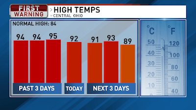
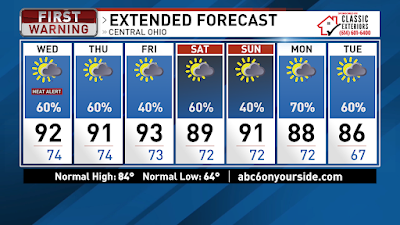
We hit 95 for the high yesterday, for the new hottest day of the year. Going forward the high temperatures will be slightly cooler, lower 90s, for the rest of the week and weekend. 80s return next week. We still have a Heat Advisory today because it will feel as hot as 100 or a little hotter this afternoon due to the high humidity. Today we have a 60% chance of rain with scattered showers and storms popping up starting midday through the early evening. The heat of the day will be the main trigger for the storms to start firing up. We are starting off with temps in the mid-upper 70s and we will warm to a high around 92 today. Areas that dodge the rain may get a little hotter. A few stray showers or storms possible this evening then most of the rain will take a break. We will repeat the process through the rest of the week and weekend. There is a slim chance for the storms to become severe with strong winds. Lots of lightning will be likely along with downpours.
For tomorrow, Central Ohio will have a 60% chance of rain with the scattered storms and a high around 91. Friday there is a little less instability, and it looks like a 40% chance of rain with a high around 93. Back to a 60% chance of rain on Saturday with a high around 89. Sunday will be a 40% chance of rain as we get a little ridge of higher pressure that may keep some rain from bubbling up. Sunday’s high will be around 91.
Pressure drops as we head into Monday and Tuesday, thanks to an approaching cold front, for a 70% chance and 60% chance of rain as high temps drop back into the mid-80s heading into the middle of the week. Have a good one!
Best,
Andrew Buck Michael


No comments:
Post a Comment